Alteration Imaged with ANT in the Athabasca Basin
Ambient Noise Tomography images of unconformity and possible alteration systems in basin sediments: recent examples from the Athabasca Basin
Introduction
Fleet Space has recently undertaken a series of Ambient Noise Tomography (ANT) surveys across mineral claims in the Athabasca basin, Canada. The models from these surveys have provided tantalizing new insights into basin structure and have even imaged zones of low and intermediate seismic velocity that are likely to be related to hydrothermal alteration. Alteration typically reduces the seismic velocity of rocks by replacing more dense and interconnected minerals, such as quartz or feldspar, with less dense and therefore lower velocity minerals such as clays.
These new models suggest ANT can detect the footprint of alteration in the basin, image the basement unconformity and also structure within the upper part of the basement. These results show ANT is a very useful exploration methodology for uranium exploration.
More broadly, the detection of seismic velocity variation within basin sedimentary rocks could prove a very useful technique when applied to other styles of basin-hosted mineralisation. For example, sedimentary copper deposits are often associated with both sedimentary facies changes and localised alteration of the sedimentary rock units.
Importantly for uranium, copper and other basin-related mineralisation styles, ANT is able to clearly image basement topography in 3D. This enables explorers to construct models of paleo-highs related to sedimentary deposition, and structural uplift zones that may post-date deposition, both of which have major controls on basin fluid flow and mineralisation.
ANT methodology
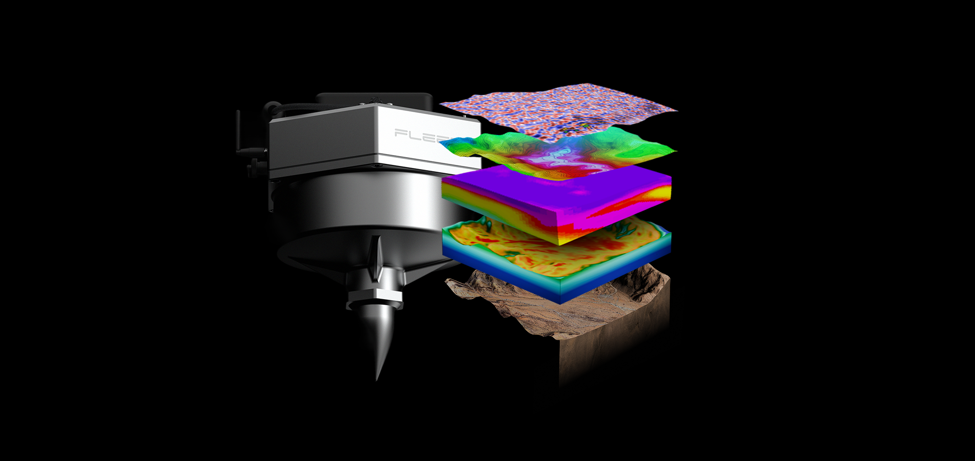
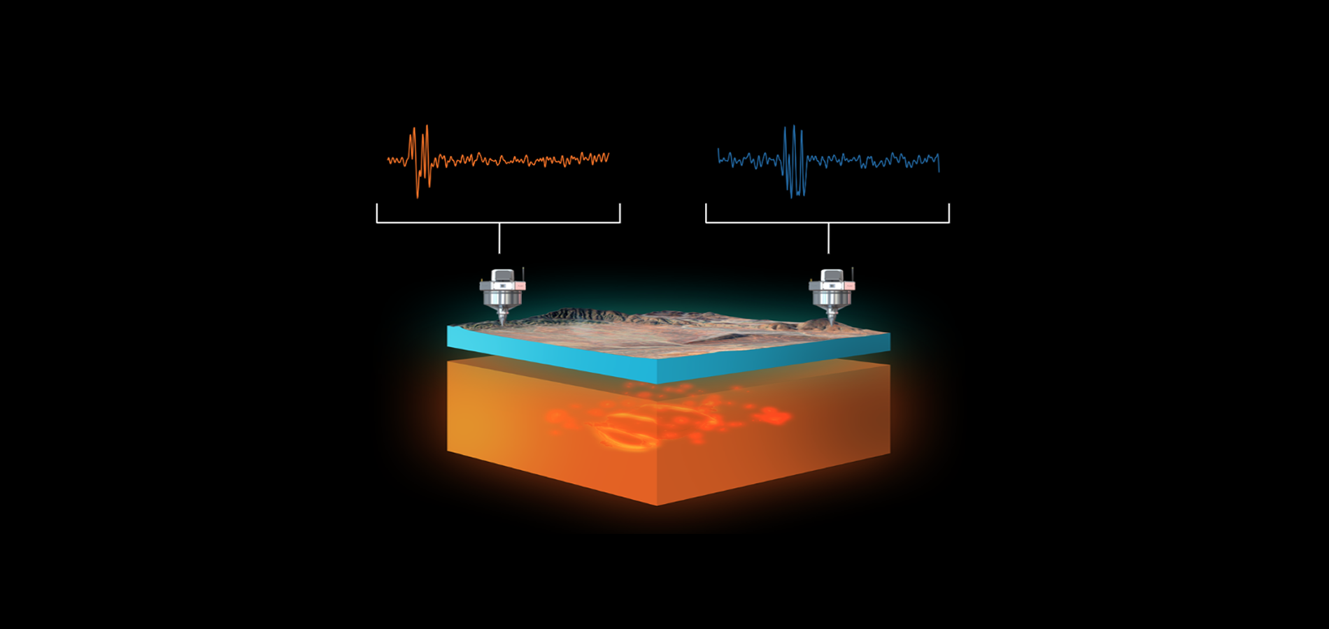
Ambient Noise Tomography (ANT) is a passive seismic technique that uses Earth’s background noise as the signal for measuring subsurface velocity structure. An array of geophones records the arrival of low frequency surface waves created by natural and anthropogenic seismic sources. This technique is used to construct estimates of cross-correlation of seismic signals between station pairs such that every receiver is turned into a virtual active source that provides information about the subsurface (Bensen et al, 2007). Inversion of the data can then be applied to construct a full 3D image of the seismic shear-wave velocity (Vs) structure at depth.
Fleet Space Technologies (Fleet) have commercialised an ANT service called ExoSphere that is notably different from the industry norms in two ways (Fig. 1; Olivier et al, 2022):
- Bespoke geophones (Geodes) that provide increased sensitivity to low frequency signals used in the ANT process.
- Connecting the Geodes to a satellite network to provide monitoring and rapid processing of uploaded data on a cloud platform.

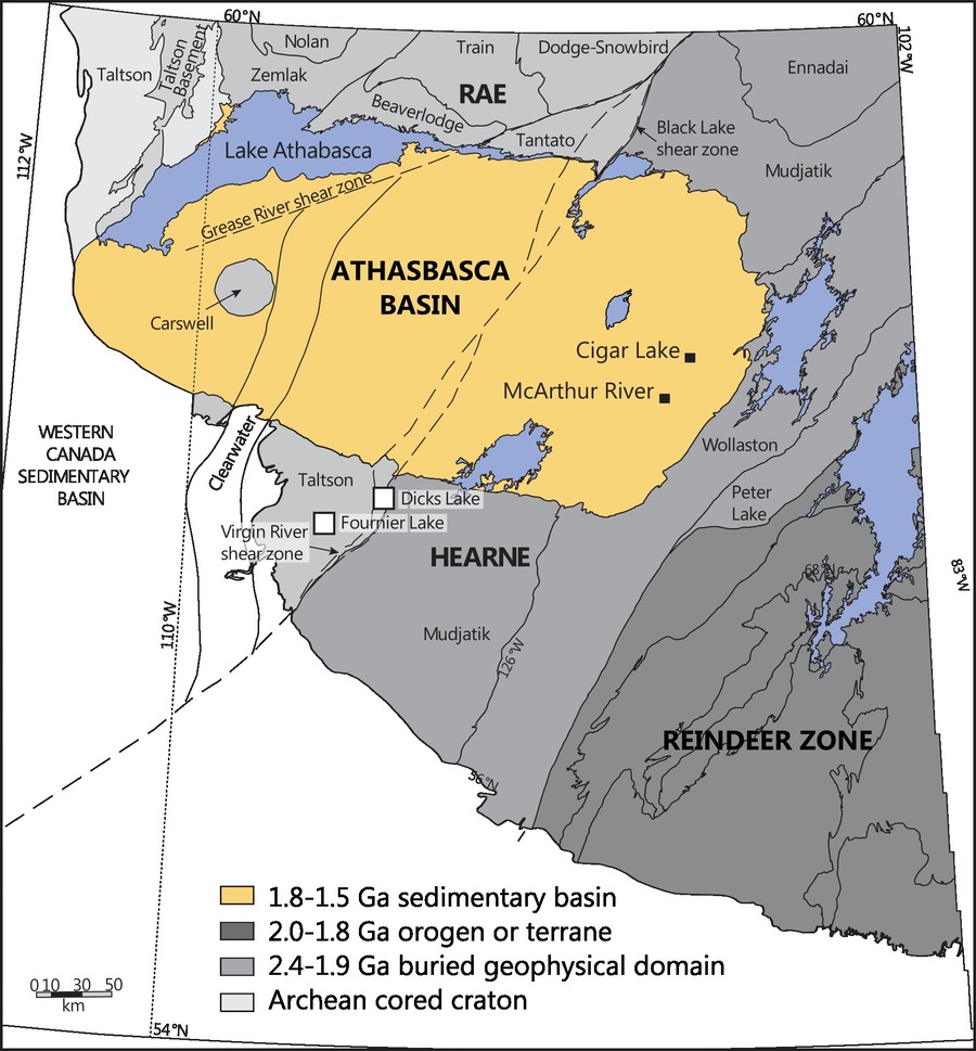
Athabasca basin geology and mineral systems
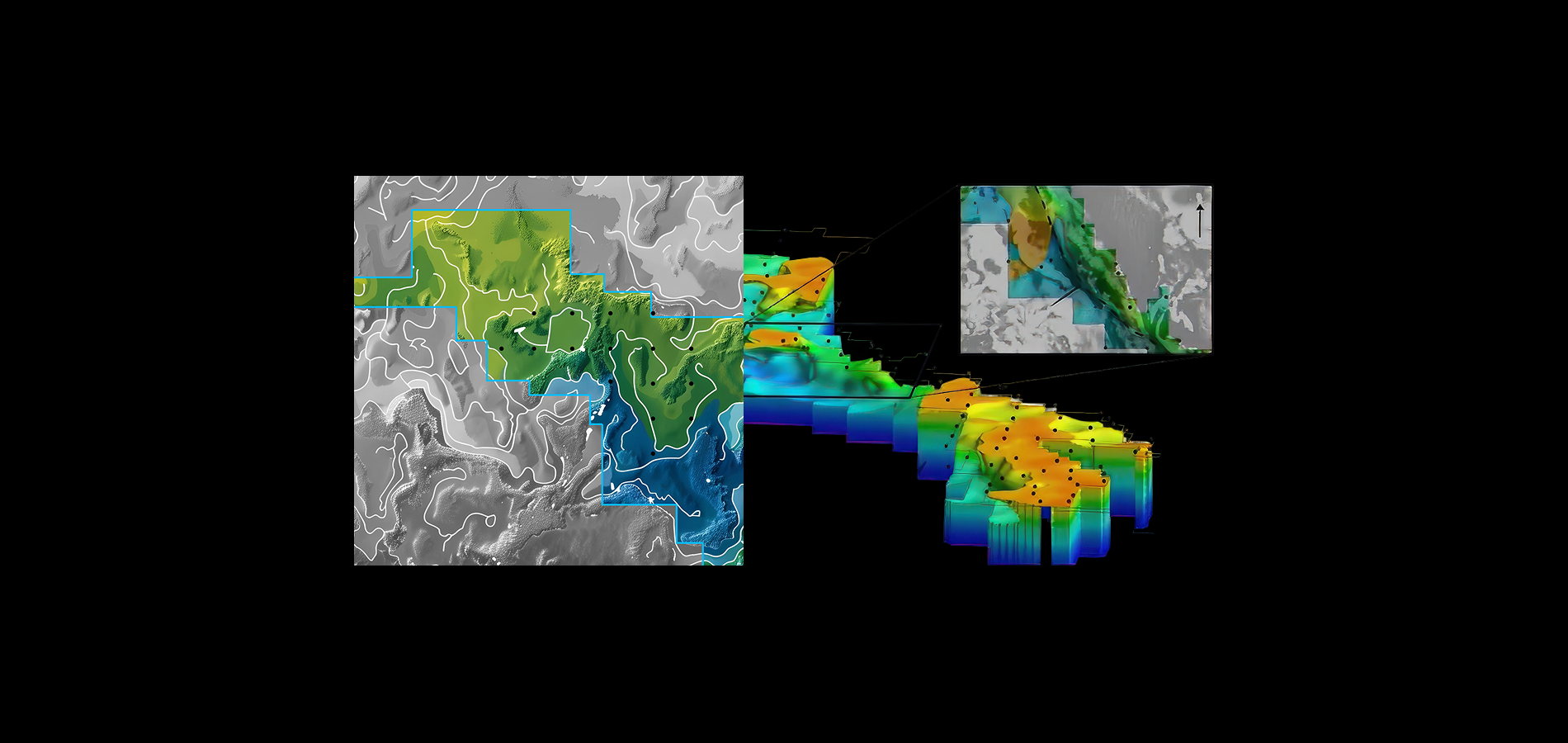
The Athabasca basin (Fig. 2) hosts the world's largest known high-grade, unconformity-related uranium deposits.The basin formed in the Paleoproterozoic and is filled by sequences of sandstone and shale that sit above Archean to Paleoproterozoic basement. The unconformity between basin sedimentary rocks and the underlying basement is a major site of ancient fluid flow, over multiple events. Unconformity-related uranium deposits (Fig. 3) often have a close spatial association with reactivated basement faults that intersect the unconformity surface (Jefferson et al., 2007; Potter and Wright, 2015). Often these basement fault systems contain graphite, and can be detected using electromagnetic methods. Exploration targeting is therefore largely focussed on structural sites within the basin combined with the presence of conductivity zones within the basement.

Summary of ANT survey results
Fleet Space has been working with two exploration companies in the Athabasca basin, Iso Energy and Terra Uranium. Both exploration projects are focussed on uranium mineralization and are at early to advanced stages of exploration.
IsoEnergy (CVE: ISO)
IsoEnergy has undertaken ANT surveys in the Athabasca Basin, on their Larocque East project
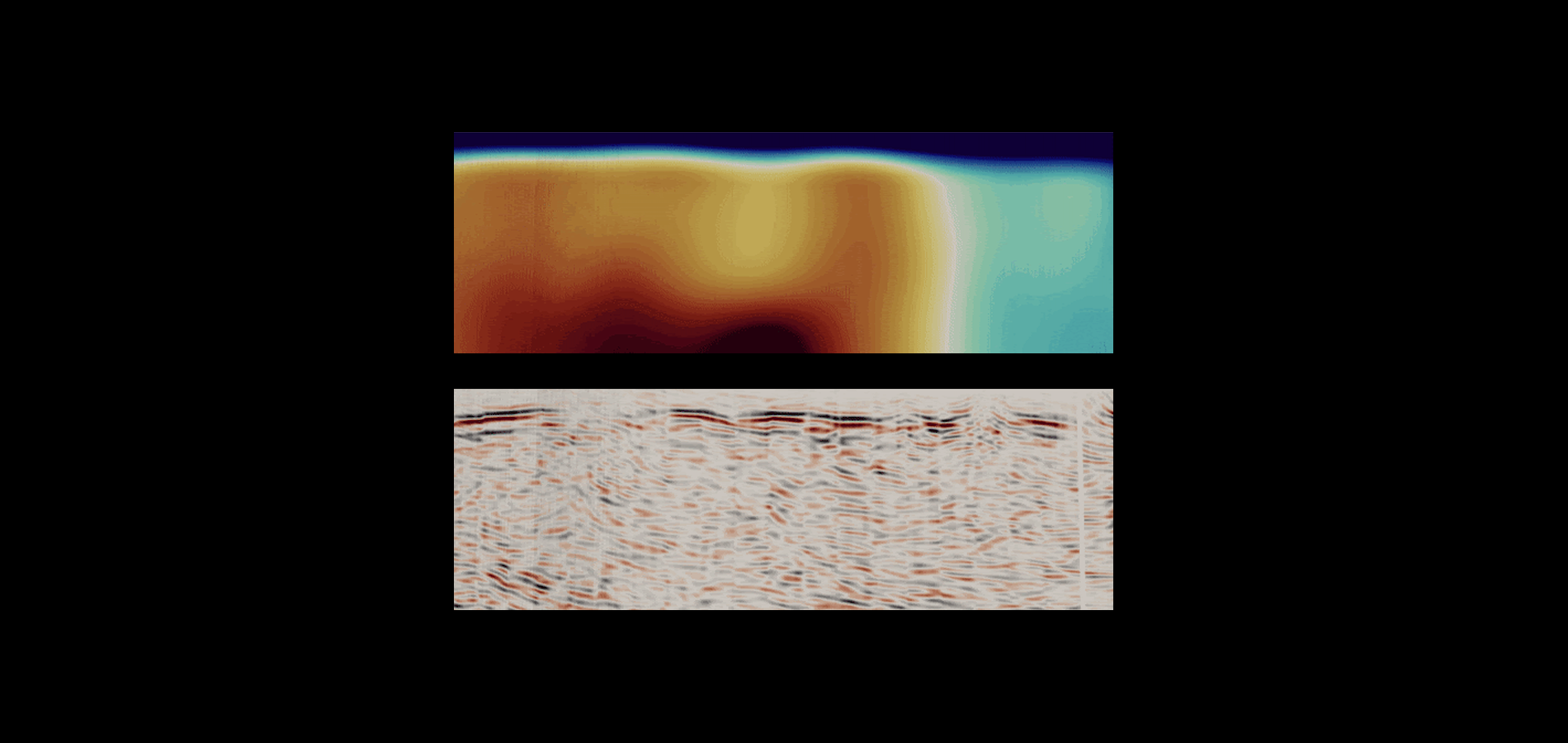
that hosts the Hurricane deposit and the early-stage Hawk exploration project. Potentially favourable conductive hosts rocks have been mapped by previous ground EM and airborne ZTEM surveys. On both projects, the ANT surveys show coincidence between conductor traces and low velocity ANT anomalies. At Larocque East, the ANT surveys show coincidence between conductor traces and low velocity ANT anomalies. The ANT survey results are shown as a velocity model that highlights two low velocity zones (blue) in the east of the survey area that have a similar velocity response as the Hurricane deposit (Fig. 4). These two target areas are both distinct low velocity zones located on the northern flank of the conductive trend.
The size of the potential alteration halo in sandstone as interpreted from the ANT anomaly is approximately 1km long and up to 300m wide. The low velocity zones in the basement gneiss is interpreted to be favorable for alteration of gneisses by secondary fluids, coincident with the presence of conductivity related to graphitic horizons. This fits the general model for unconformity-related uranium mineralisation in the basin and shallow basement. The two low velocity anomalies (Area A” and Area “B”) will be targeted by new exploration drilling during the winter 2024 season. Further details on IsoEnergy’s Larocque East and Hawk projects can be found on the company website.

Terra Uranium (ASX: T92)
A recent ASX Release by Terra Uranium (T92) outlines results from their Athabasca basin properties. The ANT survey was focussed on mapping the basement unconformity in detail at depths of 800 to 1,000 metres. The 3D velocity model derived from the ANT data was successful in mapping the basement unconformity as well as detecting variations in seismic velocity within both the basement and overlying sandstones (Fig. 5). Some of the velocity contrasts identified in both the basin and basement are coincident with conductors identified in both ZTEM and VTEM surveys. This led Terra Uranium to comment that “these variations could be related to changes in alteration, structure, or host lithologies related to mineralisation”. These results will be used to help target follow up drilling by the company.
Fleet Space is excited by these results and looks forward to the drilling results to see if lithological variation can explain the seismic velocity zones identified in the ANT surveys.

Summary
ANT surveys over uranium prospects in the eastern Athabasca basin are able to clearly image the basal unconformity between the sedimentary rocks and crystalline basement. The ANT models also show velocity features within the Athabasca basin sedimentary rocks, including low to intermediate velocity zones that may correspond to zones of alteration. These lower velocity features associated with conductivity zones are of high priority for further exploration drilling.
Acknowledgements
This article has been prepared by Anthony Reid and Bronwyn Murphy, Fleet Space, in collaboration with the teams of IsoEnergy and Terra Uranium. In particular we thank Darryl Clark and Dan Brisbin, IsoEnergy, for comments on the text and the discussions with their team that have furthered our understanding of uranium mineral systems and interpretation of ANT survey results.
References
Card, C.D., Bethune, K.M., Davis, W.J., Rayner, N., and Ashton, K.E., 2014, The case for a distinct Taltson orogeny: Evidence from northwest Saskatchewan, Canada: Precambrian research, v. 255, p. 245–265.
Cuney, M., and Kyser, K., 2009, Recent and not-so-recent developments in uranium deposits and implications for exploration: Mineralogical Association of Canada, Short Course Series, volume 39.
Jefferson, C., Thomas, D., Gandhi, S., Ramaekers, P., Delaney, G., Brisbin, D., Cutts, C., Portella, P., and Olson, R., 2007, Unconformity-associated uranium deposits of the Athabasca Basin, Saskatchewan and Alberta, in Goodfellow, W.D. ed., Mineral Deposits of Canada: A Synthesis of Major Deposit-Types, District Metallogeny, the Evolution of Geological Provinces, and Exploration Methods: Geological Association of Canada, Mineral Deposits Division, p. 273–305.
Jefferson, C. W., Thomas, D., Quirt, D., Mwenifumbo, C. J., and Brisbin, D., 2007, Empirical models for Canadian unconformity-associated uranium deposits, in Milkereit, B. ed., Proceedings of Exploration 07: Fifth Decennial International Conference on Mineral Exploration:, p. 741–769.
Potter, E.G., and Wright, D.M., 2015, Targeted Geoscience Initiative 4: Unconformity-related Uranium Systems, Natural Resources Canada/CMSS/Information Management.
You might also like